

Early Afternoon Update — Some Heat Relief Out There; Beryl Will Soon Be a Hurricane
HEAT ADVISORIES ISSUED
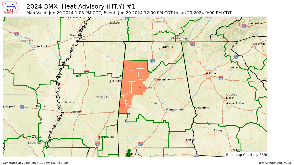
The NWS has issued a Heat Advisory. For counties in the west, the advisory is in effect until 9 PM CDT this evening. The advisory will be in effect for the entire area from 10 AM to 7 PM CDT Sunday. Heat index values are expected to reach up to 105 today and up to 108 tomorrow. The affected counties include Fayette, Greene, Lamar, Marion, Pickens, Sumter, Tuscaloosa, Walker, and Winston today and all of central Alabama tomorrow.
Hot temperatures and high humidity can lead to heat illnesses, so it’s important to stay safe. Drink plenty of fluids, stay in an air-conditioned room, avoid the sun, and check on relatives and neighbors. Never leave young children and pets unattended in vehicles. If you work or spend time outside, try to reschedule strenuous activities to early morning or evening. Wear lightweight and loose-fitting clothing, and take frequent rest breaks in shaded or air-conditioned areas. Be aware of the signs of heat exhaustion and heat stroke, and if anyone is overcome by heat, move them to a cool, shaded location and call 911 immediately.
STORMS LIKELY AT TIMES THROUGH THE WEEKEND
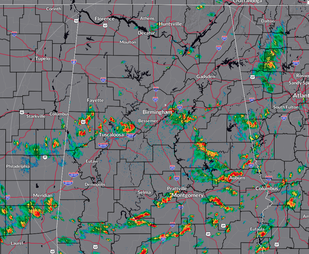
We have a wide range of temperatures out there at 1 PM as some locations are currently seeing some showers and storms. We’re ranging from as cool as 76 in Bessemer, to as hot as 90 in Jasper and Selma. The activity is all pushing very slowly to the east, but is allowing for those lucky locations to receive a temporary break from the heat. Highs should top out in the lower to mid 90s. We’ll keep a chance of showers and storms through the evening, but most activity should have dissipated by the late night. Overnight lows will be in the lower to mid 70s.
Unsettled weather continues on Sunday, as scattered to numerous showers and storms will be likely, mainly during the afternoon and evening. It will also continue to be hot and muggy as highs reach the mid to upper 90s for most.
A NORMAL SUMMER FORECAST FOR THE SHORT WORK WEEK & THE HOLIDAY
Believe it or not, a cold front will work through much of the area on Monday that will bring us a little relief from the mugginess. Skies will be partly to mostly sunny across the area as the front makes it to around the I-85 corridor. Highs will still be hot, as we’ll hit the upper 80s to the upper 90s, even though heat index values should stay out of the 100s for much of the area.
Ridging begins to build back in on Tuesday, allowing the mugginess to start returning. A few isolated to scattered showers may be possible over the east and southeastern locations, while the rest of Central Alabama looks to stay rain-free. Highs throughout the 90s.
The rest of the week looks like your typical summer forecast for Central Alabama. Skies will be partly sunny with a chance of widely scattered showers and storms on Wednesday through Friday with highs well up into the 90s, with heat advisories possible each day.
BERYL FORECAST TO BE A MAJOR HURRICANE
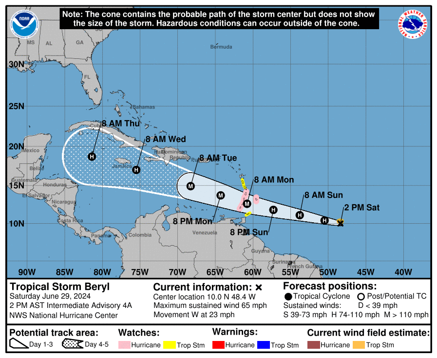
As of 12 PM CST, Beryl is located at 10.0°N latitude and 48.4°W longitude, which is about 785 miles east-southeast of Barbados. The storm has maximum sustained winds of 65 mph and is moving west at 23 mph. The central pressure of the storm is 998 mb.
A Tropical Storm Watch has been issued for Dominica. A Hurricane Watch is in effect for Barbados, St. Lucia, St. Vincent and the Grenadine Islands, and Grenada. A Tropical Storm Watch is in effect for Martinique, Dominica, and Tobago. People in the Lesser Antilles should closely monitor Beryl’s progress, as additional watches and warnings may be issued later.
Tropical Storm Beryl is moving west and is expected to continue this movement for the next few days. It’s likely to cross the Windward Islands late Sunday night and Monday. Beryl’s winds are currently at 65 mph, but the storm is expected to strengthen rapidly and become a major hurricane before reaching the Windward Islands. Tropical-storm-force winds extend up to 45 miles from the center of the storm.
Hurricane conditions are possible in areas under the hurricane watch by Sunday night or Monday morning. Tropical storm conditions could start by late Sunday. A life-threatening storm surge could raise water levels by 5 to 7 feet in areas of onshore flow within the hurricane watch areas, accompanied by large, destructive waves. Beryl is expected to bring 3 to 6 inches of rain to Barbados and the Windward Islands from Sunday night into Monday, which could lead to flooding in vulnerable areas. Swells generated by Beryl are expected to reach the Windward and southern Leeward Islands by late Sunday, causing dangerous surf and rip current conditions.
OTHER TROPICAL ACTIVITY
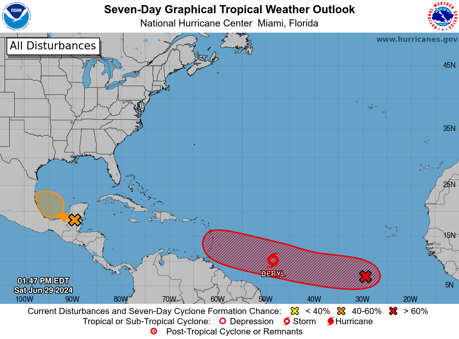
A broad area of low pressure, known as Invest 94L, is forecast to form over the Bay of Campeche tonight or early Sunday, where conditions appear generally conducive for further development. A tropical depression could form before the system moves inland again early next week over Mexico. Interests along the Gulf coast of Mexico should monitor the progress of this system. Regardless of development, heavy rainfall associated with the area of low pressure will affect portions of Central America and Mexico through early next week. This system has a medium chance of tropical cyclone development over the next 48 hours.
An eastern Atlantic tropical wave is near 29W from 13N southward, or several hundred nautical miles south-southwest of the Cabo Verde Islands, moving west at 10 to 15 knots. Scattered moderate convection is on either side of the wave axis from 4N to 9N between 26W and 33W. Environmental conditions appear conducive for additional development of this system, and a tropical depression could form by the middle of next week while it moves generally westward at 15 to 20 mph across the eastern and central tropical Atlantic.
A tropical wave is moving across the Lesser Antilles with its axis along 61W/62W from 19N southward into northeastern Venezuela, moving west at 10 to 15 knots. Clusters of moderate to isolated strong convection are noted mainly on the eastern side of the wave axis from 8N to 13N between 57W and 63W.
Category: Alabama's Weather, ALL POSTS, Tropical
About the Author (Author Profile)
Scott Martin is an operational meteorologist, professional graphic artist, musician, husband, and father. Not only is Scott a member of the National Weather Association, but he is also the Central Alabama Chapter of the NWA president. Scott is also the co-founder of Racecast Weather, which provides forecasts for many racing series across the USA. He also supplies forecasts for the BassMaster Elite Series events including the BassMaster Classic.Subscribe
If you enjoyed this article, subscribe to receive more just like it.


