

Saturday Briefing Video — Scattered Storms Through the Weekend; We Now Have Tropical Storm Beryl
STORMS LIKELY AT TIMES THROUGH THE WEEKEND
It’s no surprise, as we’ll be hot and muggy across Central Alabama today. However, there will be scattered to numerous showers and storms mainly during the afternoon and evening across the southeastern 3/4ths of the area, with smaller chances over the northwestern 1/4. Heat indices will be in the upper 90s to around 105º with highs in the upper 80s to the mid 90s.
Unsettled weather continues on Sunday, as scattered to numerous showers and storms will be likely, mainly during the afternoon and evening. It will also continue to be hot and muggy as highs reach the upper 80s to the mid 90s.
A NORMAL SUMMER FORECAST FOR THE SHORT WORK WEEK & THE HOLIDAY
Believe it or not, a cold front will work through much of the area on Monday that will bring us a little relief from the mugginess. Skies will be partly to mostly sunny across the area as the front makes it to around the I-85 corridor. Highs will still be hot, as we’ll hit the upper 80s to the upper 90s, even though heat index values should stay out of the 100s for much of the area.
Ridging begins to build back in on Tuesday, allowing the mugginess to start returning. A few isolated to scattered showers may be possible over the east and southeastern locations, while the rest of Central Alabama looks to stay rain-free. Highs throughout the 90s.
The rest of the week looks like your typical summer forecast for Central Alabama. Skies will be partly sunny with a chance of widely scattered showers and storms on Wednesday through Friday with highs well up into the 90s, with heat advisories possible each day.
UPDATE ON THE TROPICS
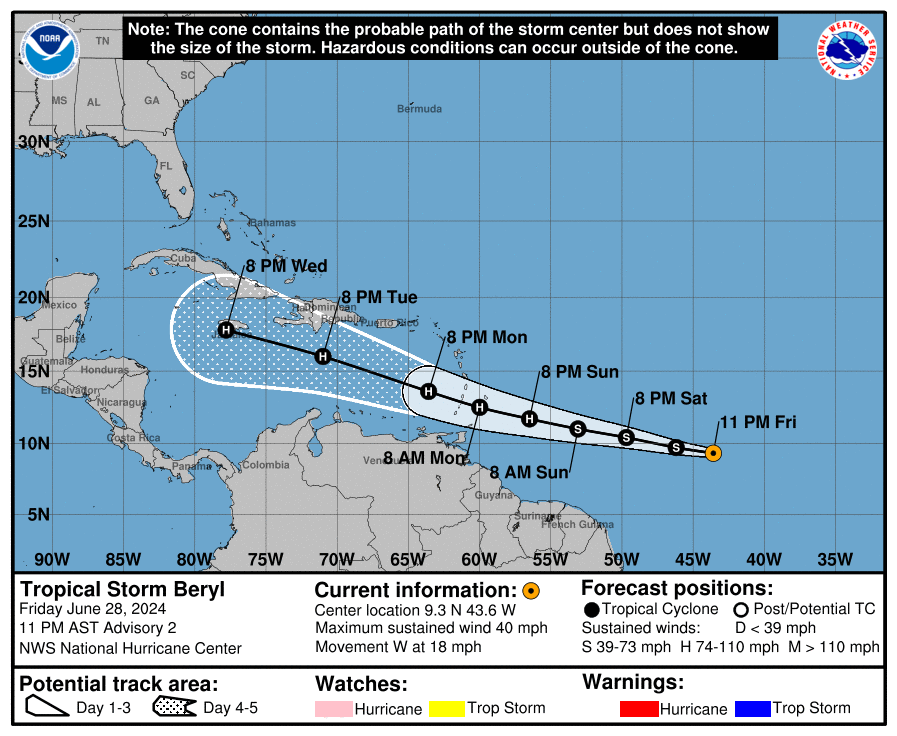
Tropical Storm Beryl has formed and is on its way to becoming a hurricane. Beryl is expected to strengthen as it moves towards the Windward Islands, possibly reaching hurricane status by late Sunday night or Monday. As of the latest update, Beryl is located at latitude 9.3 North and longitude 43.6 West, moving west at about 18 mph (30 km/h). It’s expected to keep this westward to west-northwestward track for the next few days, bringing it across the Windward Islands late Sunday night into Monday. Maximum sustained winds are around 40 mph, with stronger gusts. It’s forecasted to keep getting stronger and become a hurricane in the next couple of days. Tropical-storm-force winds currently extend up to 45 miles from the center of the storm. The minimum central pressure is estimated to be 1006 mb (29.71 inches).
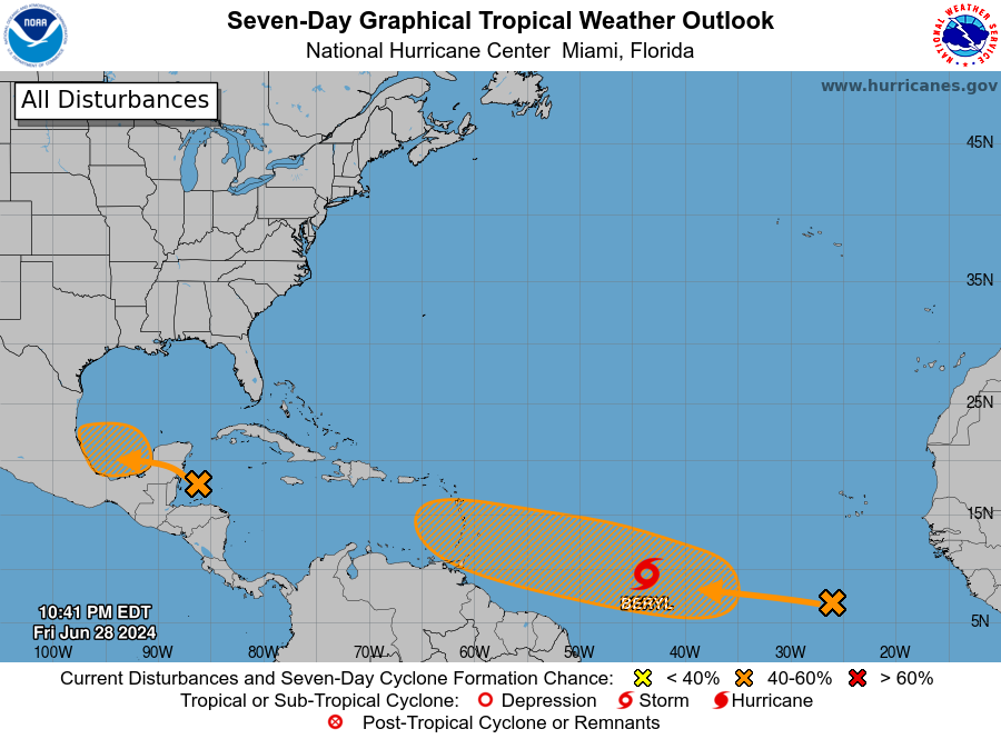
In the northwestern Caribbean and southwestern Gulf of Mexico, a broad area of low pressure is producing widespread but disorganized showers and thunderstorms. Development isn’t expected before it moves over the Yucatán Peninsula on Saturday. However, conditions could become favorable for development when it reaches the Bay of Campeche on Saturday night or early Sunday. A tropical depression might form before it moves inland over Mexico early next week. Regardless, heavy rain will affect parts of Central America and Mexico through early next week, with a 40% chance of development over the next two and seven days.
Meanwhile, in the eastern tropical Atlantic, a tropical wave is several hundred miles south-southwest of the Cabo Verde Islands. This wave is creating disorganized showers and thunderstorms, with conditions possibly allowing for further development. A tropical depression could form by mid-next week as it moves westward at 15 to 20 mph. There’s a low chance of development over the next 48 hours but a 40% chance over the next seven days.
ON THIS DAY IN WEATHER HISTORY
1987… Thunderstorms produced severe weather in the Ohio Valley and the Great Lakes Region, with reports of large hail and damaging winds most numerous in Ohio, Indiana and Michigan. Thunderstorms spawned four tornadoes in Michigan. A tornado near Clare, MI was accompanied by softball size hail. In Colorado, an untimely winter-like storm blanketed Mount Evans with six inches of snow.
SEVERE WEATHER SAFETY
Weather can be unpredictable, catching us off guard with its sudden changes. From thunderstorms to tornadoes or flash floods, being ready beforehand can be a lifesaver. Alabama, with its varied climate, faces its share of severe weather. That’s why having a solid safety plan is so important for everyone. Check out our Severe Weather Safety Guide for valuable tips on how to stay safe when severe weather is on the horizon.
BEACH FORECAST CENTER
Please visit our Beach Forecast Center page to access the most up-to-date weather and rip current forecasts for the beaches spanning from Fort Morgan to Panama City. On this platform, you can choose the forecast specific to the region you intend to visit, ensuring you have accurate and relevant information for your plans.
ADVERTISE ON THE BLOG
Ensure you don’t miss this opportunity! Allow us to tailor a bespoke package designed to meet the unique requirements of your organization. Our offerings are creative, flexible, and affordably priced. For further details and inquiries, please reach out to Bill Murray at (205) 687-0782.
E-FORECAST SIGN UP
Receive the Alabama Weather Blog’s comprehensive Seven-Day Forecast directly to your inbox via email, delivered twice daily. Recognized as the most detailed weather forecast accessible in Central Alabama, our service ensures you stay informed and prepared. Subscribe now to access this valuable resource at no cost!
Category: Alabama's Weather, ALL POSTS, Tropical, Weather Xtreme Videos
About the Author (Author Profile)
Scott Martin is an operational meteorologist, professional graphic artist, musician, husband, and father. Not only is Scott a member of the National Weather Association, but he is also the Central Alabama Chapter of the NWA president. Scott is also the co-founder of Racecast Weather, which provides forecasts for many racing series across the USA. He also supplies forecasts for the BassMaster Elite Series events including the BassMaster Classic.Subscribe
If you enjoyed this article, subscribe to receive more just like it.


