

Midday Nowcast: Big Heat and Big Storms Today
Scattered showers and storms will return to Alabama today, but we can’t promise rain for everyone. Where storms do form, they could be strong. The SPC has a “slight risk” (level 2/5) defined today for a few counties in West Alabama, otherwise most of the western half of the state is in a “marginal risk” (level 1/5).
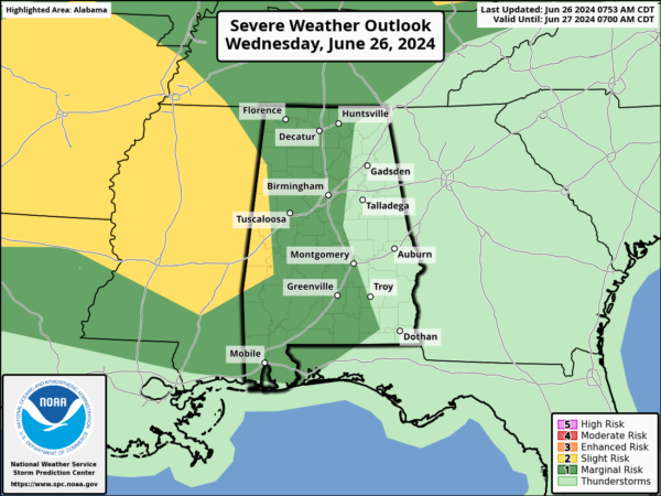
The main threat will come from strong straight line winds and hail; there is an almost zero tornado threat. Most of the showers and stronger storms will come this afternoon and early tonight. While we wait on the storms, it is another blistering hot day with upper 90s and low 100s covering Alabama.
BIRMINGHAM ALMANAC: For June 26th, the average high for Birmingham is 90° and the average low is 71°. The record high is 100° set in 2016, while the record low is 50° set in 1974. We average 0.16” of precipitation on this date, and the record value is 1.68” set in 2001.
ACROSS THE USA: Monsoon-like conditions will persist across the Four Corners Region over the next several days. Heavy to excessive rainfall may lead to instances of flash flooding. Strong to severe thunderstorms are possible this afternoon across portions of the Great Plains, Lower Mississippi Valley and Mid-Atlantic. Heat wave continues this week from the Southern Plains through Southeast.
TOMORROW: Scattered showers and storms will remain in the forecast, with the higher coverage over southern portions of the state, and during the afternoon and evening hours. It won’t be quite as hot as afternoon highs should be in the low 90s.
FRIDAY AND THE WEEKEND: Routine summer weather is in the forecast. Expect partly sunny, hot, humid days with the usual risk of scattered showers and storms on a daily basis generally during the afternoon and evening hours. Highs should be in the low to mid 90s, and with the higher humidity levels, heat index values should be near the 100° mark. The chance of any one given community seeing rain will be in the 40-50% range.
NEXT WEEK: Hotter temperatures will return as the upper ridge will strengthen, and rain chances look to decrease. Expect highs to return to the upper 90s and likely some low 100s. A few afternoon showers and storms are still possible… becoming a little more numerous by Independence Day and Friday.
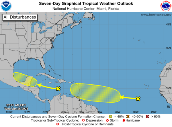
IN THE TROPICS: Two areas the NHC is monitor for potential development over the next week.
1. Western Caribbean/Southwestern Gulf of Mexico (AL94): A tropical wave over the central Caribbean Sea is producing disorganized shower activity while it moves quickly westward at around 25 mph. Environmental conditions could become more conducive for some gradual development in a couple of days over the western Caribbean Sea or over the southwestern Gulf of Mexico during the weekend. Formation chance through 7 days…low…20 percent.
2. Eastern Tropical Atlantic: A tropical wave located a few hundred miles southwest of the Cabo Verde Islands is producing disorganized showers and thunderstorms. Some slow development of this system is possible during the next several days while it moves generally westward across the central and western tropical Atlantic at 15 to 20 mph. Formation chance through 7 days…low…30 percent.
Next names up are Beryl and Chris.
BEACH FORECAST CENTER: Highs in the upper 80s and lower 90s with daily afternoon storms. Water temperatures are very warm with mid-80s being reported up and down the Northern Gulf Coast. Again, PLEASE pay attention to the Rip Current Flags System at each beach for the update on rip currents. Low to Moderate rip currents are being reported from Dauphin Island east to Panama City. Get the latest weather and rip current forecasts for the beaches from Fort Morgan to Panama City on our Beach Forecast Center page. There, you can select the forecast of the region that you are interested in visiting.
WORLD TEMPERATURE EXTREMES: Over the last 24 hours, the highest observation outside the U.S. was 121.1F at Bandar-E-Dayyer, Iran. The lowest observation was -102.1F at Concordia, Antarctica.
CONTIGUOUS TEMPERATURE EXTREMES: Over the last 24 hours, the highest observation was 120F at Death Valley, CA. The lowest observation was 32F at Bynum, MT.
Category: Alabama's Weather, ALL POSTS
About the Author (Author Profile)
Macon, Georgia Television Chief Meteorologist, Birmingham native, and long time Contributor on AlabamaWX. Stormchaser. I did not choose Weather, it chose Me. College Football Fanatic. @Ryan_StinnetSubscribe
If you enjoyed this article, subscribe to receive more just like it.


