

Another Sizzling Summer Day; Mostly Dry
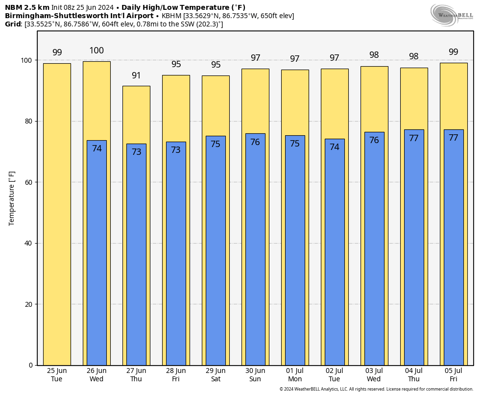
HOT: With a mostly sunny sky, we expect a high in the 97-101 degree range for most of Alabama today. Thankfully humidity levels will remain relatively low for the northern half of the state, but a heat advisory is in effect for the southwest counties, where humid air is in place. A few spotty showers could form during the heat of the day across far South Alabama, but most places will be dry.
REST OF THE WEEK: The air aloft will be a little colder, and the air a little more unstable, and with rising moisture levels we will bring in the chance of a few scattered, random showers and thunderstorms on a daily basis tomorrow through Friday. Most, but not necessarily all, of the storms will come during the afternoon and evening hours (around 2 to 10 p.m.), and the chance of any one spot seeing rain daily is in the 25-30 percent range. Heat levels come down a bit with highs in the low to mid 90s, but with higher dew points it will pretty much feel the same.
THE ALABAMA WEEKEND: No real change. It is summer in Alabama; expect hot, humid weather Saturday and Sunday with the risk of a pop-up afternoon shower or thunderstorm both days. Highs hold in the 90s. The classic summer weather pattern continues through much of next week… See the video briefing for maps, graphics, and more details.
TROPICS: A westward-moving tropical wave located near the Windward Islands is producing disorganized showers and thunderstorms. Environmental conditions appear conducive for slow development once the wave reaches the western Caribbean late this week. If anything develops, it will most likely head for Mexico; NHC gives it only a 20 percent chance of becoming a tropical storm for now.
No tropical systems are expected near the Central Gulf Coast (Gulf Shores to Panama City Beach) through July 4.
ON THIS DATE IN 1957: Audrey reached hurricane strength; it was moving northward through the Gulf of Mexico; it would make landfall two days later near Sabine Pass and would be one of the deadliest hurricanes in U.S. history.
ON THIS DATE IN 1967: Three F3 tornadoes crossed the Netherlands on this day, killing seven people and producing widespread damage.
Look for the next video briefing here by 3:00 this afternoon… enjoy the day!
Category: Alabama's Weather, ALL POSTS, Weather Xtreme Videos
About the Author (Author Profile)
James Spann is one of the most recognized and trusted television meteorologists in the industry. He holds the AMS CCM designation and television seals from the AMS and NWA. He is a past winner of the Broadcast Meteorologist of the Year from both professional organizations.Subscribe
If you enjoyed this article, subscribe to receive more just like it.


