
Midday Nowcast: Mainly Sunny and Hot with Showers and Storms to the South
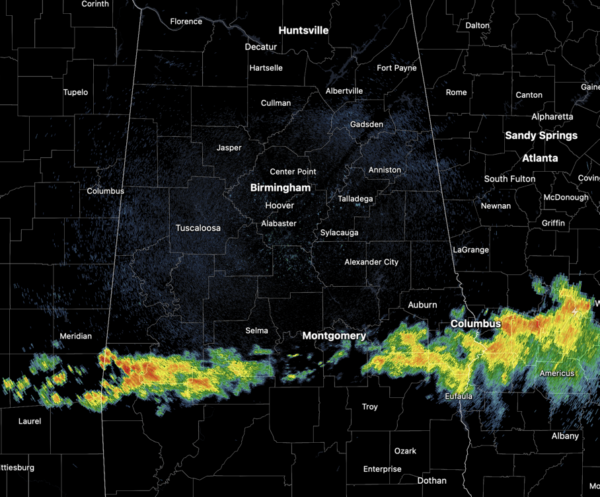
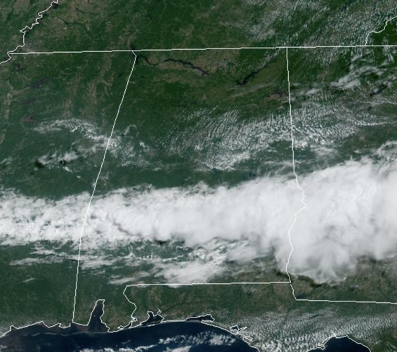
The scattered showers and storms from this morning have pushed south and are over the southern half of the state this afternoon. For North/Central Alabama this afternoon is mostly sunny and hot, but with lower humidity levels. Highs are in the mid to upper 90s for most communities.
BIRMINGHAM ALMANAC: For June 21st, the average high for Birmingham is 89° and the average low is 70°. The record high is 99° set in 1981, while the record low is 54° set in 1972. We average 0.15” of precipitation on this date, and the record value is 2.28” set in 1987.
TOMORROW AND WEDNESDAY: Tomorrow will be a hot and mostly dry day with a highs again in the mid and upper 90s. Rain chances are very low, but not zero, but really worth mentioning in the forecast. On Wednesday, scattered showers and storms are possible statewide as the air becomes more unstable and moisture levels rise. It won’t rain everywhere, but rain chances will be in the 40-50%t range. Otherwise, expect a mix of sun and clouds with a high in the mid 90s.
ACROSS THE USA: An ongoing heat wave will continue today and Tuesday from much of the Great Plains to the lower Mississippi River Valley and into northern Florida. Dangerous heat is also expected in southern California and Puerto Rico. Scattered severe thunderstorms will be possible over parts of the Upper Midwest today with destructive wind gusts possible for parts of Minnesota into Wisconsin.
THURSDAY THROUGH THE WEEKEND: Routine summer weather is the story for the end of the week and the weekend. Partly sunny, hot, humid days with a few random, scattered, mostly afternoon and evening showers and storms possible. Highs will be in the mid 90s on most days and that heat index will likely be over 100° at times. Rain chances will be in the 20-30% Thursday through Saturday, and look to increase some to the 30-40% Sunday.
NEXT WEEK: Not much change; highs in the 90s, lows in the 70s. Partly sunny days; the risk of a pop up afternoon shower or storm in scattered spots.
IN THE TROPICS: All is quiet across the Gulf of Mexico, Caribbean Sea, and Atlantic Ocean with no tropical cyclone development expected the next seven days.

BEACH FORECAST CENTER: Highs in the upper 80s and lower 90s with daily afternoon storms. Water temperatures are very warm with mid-80s being reported up and down the Northern Gulf Coast. Again, PLEASE pay attention to the Rip Current Flags System at each beach for the update on rip currents. Moderate rip currents are being reported from Dauphin Island east to Destin, while Panama City is reporting High rip current threats.
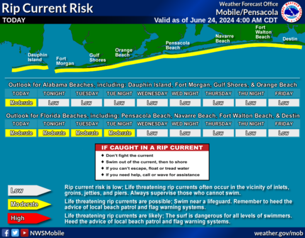
Get the latest weather and rip current forecasts for the beaches from Fort Morgan to Panama City on our Beach Forecast Center page. There, you can select the forecast of the region that you are interested in visiting.
WORLD TEMPERATURE EXTREMES: Over the last 24 hours, the highest observation outside the U.S. was 122.9F at Nasiriya, Iraq. The lowest observation was -94.7F at Concordia, Antarctica.
CONTIGUOUS TEMPERATURE EXTREMES: Over the last 24 hours, the highest observation was 115F at Phoenix, AZ. The lowest observation was 29F at Mackay, ID.
Category: Alabama's Weather, ALL POSTS
About the Author (Author Profile)
Macon, Georgia Television Chief Meteorologist, Birmingham native, and long time Contributor on AlabamaWX. Stormchaser. I did not choose Weather, it chose Me. College Football Fanatic. @Ryan_StinnetSubscribe
If you enjoyed this article, subscribe to receive more just like it.


