
Your Sunday Nowcast: A Few Showers Tonight, Otherwise Hot
GOES satellite imagery reveals the only clouds across Alabama as we go into the noon hour are puffy fair weather cumulus. But looking upstream, we see more widespread cloudiness associated with a cold front nearing our state. They have breached the I-40 Corridor in western Tennessee. There are even a few showers from northeast of Jackson, TN, to the Nashville area.
Temperatures this morning started off in the middle to upper 60s across North and Central Alabama, with the exception of the urban heat island in Birmingham, where the mercury was in the lower 70s overnight.
Temperatures are warming quickly and are already in the lower to middle 90s. The state’s hotspot at this hour is 99F at Scottsboro. It is 96F at Birmingham.
Afternoon highs will look like this today:
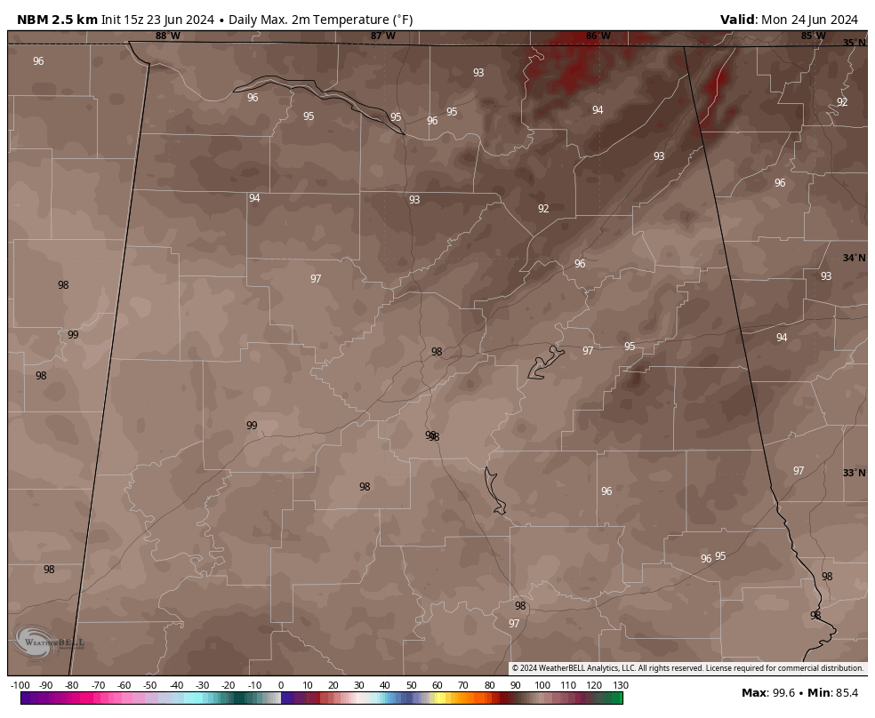
Those readings are generally 6-10 degrees above normal for today.
Heat index readings will be in the 99-103F range today, so take it easy with the heat. For the next few days, they will be approaching 105F in spots, which is where they reach the dangerous level when heat advisories are required.
A few showers or storms could reach our Tennessee Valley counties late this afternoon or evening. They should reach the I-20 Corridor around 2-3 a.m., and should be weakening by then. The front should be south of Birmingham by late morning, and slightly lower temperatures will be the main effect. Temperatures will still be hot, in the middle and upper 90s with heat index values 3-4 degrees hotter. Heat index values will reach 101-105, probably peaking on Wednesday.
Tuesday will see those slightly slightly lower dewpoints and dry conditions, but it will still be hot and humid. Wednesday will feature better rain chances as all that heat and moisture pools over Alabama in the face of a northwesterly flow that could bring a strong complex of storms into the state.
The rest of the week will feature scattered showers and storms, but things will dry out heading into the weekend. Highs will be in the 90s, lows in the 70s.
Severe weather is expected today from New England back into western Tennessee. There is an enhanced risk (3 of 5) over parts of Vermont, New Hampshire, Maine, New York, and Massachusetts. There is actual a 10% tornado risk in that area.
The tropics are fairly quiet. The NHC is still tracking the disturbance moving into Mexico today, but it is mostly inland now. The next area to watch will be the southwestern Caribbean around Nicaragua next weekend, but the threat is low.
Category: Alabama's Weather, ALL POSTS, Tropical
About the Author (Author Profile)
Bill Murray is the President of The Weather Factory. He is the site's official weather historian and a weekend forecaster. He also anchors the site's severe weather coverage. Bill Murray is the proud holder of National Weather Association Digital Seal #0001 @wxhistorianSubscribe
If you enjoyed this article, subscribe to receive more just like it.


