

Dry and Hot, Getting Hotter; More Tropical Troubles
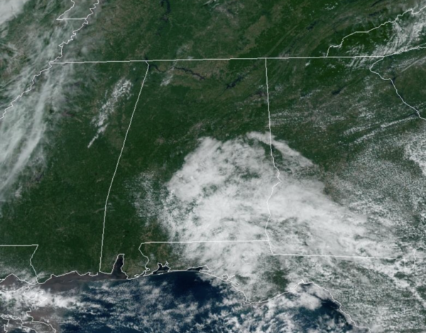
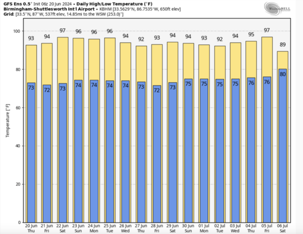
New day, same forecast with mainly dry and hot weather in place across Alabama. We continue to see a mix of sun and clouds, and rain chances are less than 10%, but a stray pop-up shower or two cannot be ruled out. Afternoon highs today are in the low 90s areawide, while tomorrow will feature mid-90s for most of North/Central Alabama.
BIRMINGHAM ALMANAC: For June 20th, the average high for Birmingham is 89° and the average low is 70°. The record high is 101° set in 1933, while the record low is 54° set in 1985. We average 0.16” of precipitation on this date, and the record value is 1.21” set in 1920.
SUMMER SOLSTICE: Today is the Summer Solstice which occurs at 3:50PM CDT; this is the moment the sun is directly over the Tropic of Cancer (23.5°N). This is the day with the most of amount of daytime as sunrise occurred at 5:37AM in Birmingham and sunset will occur at 8:00PM. Total amount of daylight today for Birmingham will be 14 hours 22 minutes and 41 seconds, which is one second longer than yesterday. After today, the days slowly start to get shorter until we reach the Winter Solstice in December.
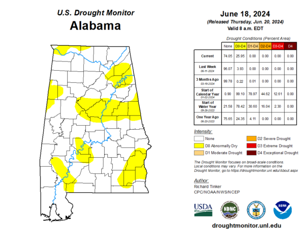
DROUGHT MONITOR: The latest monitor was released today and it shows Abnormally Dry conditions starting to expand across Alabama. No areas of drought just yet, but with the continue very hot and mainly dry pattern, we could see drought conditions develop in the next few weeks.
HOT ALABAMA WEEKEND: Heat levels continue to rise with highs in the mid and upper 90s Saturday and Sunday. Moisture levels will begin to rise as well and that means those heat index values are likely to climb over 100°. A few, widely isolated afternoon showers and storms will be possible both days.
NEXT WEEK: Moisture levels continue to rise Monday through Wednesday with showers and storms increasing in number. These will be the only heat relief across Alabama as afternoon highs will continue to be in the low to mid 90s for the foreseeable future.
IN THE TROPICS: Tropical Storm Alberto made landfall in Mexico this morning and will continue to dissipate in the coming days as it moves through the mountains of northern Mexico.
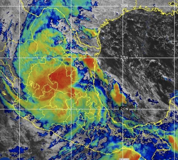
Latest update from NHC has Alberto weakening to a tropical depression. The center of Alberto was located near latitude 22.3 North, longitude 99.4 West. The depression is moving toward the west near 18 mph and this motion is expected to continue through today, as Alberto moves farther inland over Mexico.
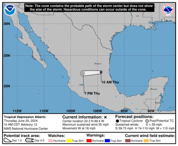
Maximum sustained winds are near 35 mph with higher gusts. Alberto is expected to continue weakening as it moves inland, and the system is likely to dissipate over Mexico later today. The estimated minimum central pressure is 999 mb (29.50 inches).
Elsewhere, in the Atlantic, in the southwestern Atlantic Ocean we now have Invest 92L which is a small area of low pressure located about 150 miles east of the northernmost Bahamas. It continues to produce disorganized shower and thunderstorm activity. While environmental conditions are only marginally conducive due to nearby dry air, further development of this system could lead to the development of a tropical depression while the low moves west-northwestward at 10 to 15 mph and approaches the northeastern coast of Florida or the Georgia coast early on Friday. An Air Force Reserve reconnaissance aircraft is scheduled to investigate this system this afternoon, if necessary. Formation chance through 48 hours…medium…40 percent.
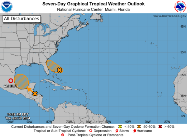
In the southwestern Gulf of Mexico, a broad area of low pressure is forecast to form over southeastern Mexico and northern Central America on Friday. Environmental conditions appear conducive for gradual development after this system moves over the Bay of Campeche on Saturday, and a tropical depression could form over the southwestern Gulf of Mexico this weekend while it moves slowly west-northwestward or northwestward. Formation chance through 7 days…medium…50 percent.
Next two names up are Beryl and Chris.
BEACH FORECAST CENTER: Dangerous and strong rip currents will continue for through Friday along the Alabama coast and the western Florida panhandle beaches. Many area beaches continue to report double red flags, meaning the water is closed to the public. Please pay attention to the flag warning system along the Northern Gulf Coast beaches as rip currents are the number one weather killer for the NWS offices in Mobile and Tallahassee which cover those beautiful white sand beaches so many of us enjoy. By the weekend, the rip current threat begins to decrease some, but still pay attention.
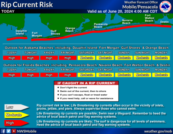
Get the latest weather and rip current forecasts for the beaches from Fort Morgan to Panama City on our Beach Forecast Center page. There, you can select the forecast of the region that you are interested in visiting.
WORLD TEMPERATURE EXTREMES: Over the last 24 hours, the highest observation outside the U.S. was 122.9F at Amarah, Iraq. The lowest observation was -103.7F at Concordia, Antarctica.
CONTIGUOUS TEMPERATURE EXTREMES: Over the last 24 hours, the highest observation was 108F at Death Valley, CA. The lowest observation was 15F at Mackay, ID.
Category: Alabama's Weather, ALL POSTS
About the Author (Author Profile)
Macon, Georgia Television Chief Meteorologist, Birmingham native, and long time Contributor on AlabamaWX. Stormchaser. I did not choose Weather, it chose Me. College Football Fanatic. @Ryan_StinnetSubscribe
If you enjoyed this article, subscribe to receive more just like it.


