

Thursday Weather Video: Heating Up!
Today is the big day! The summer solstice AND the Giants and Cardinals in a real regular season MLB game in our little Mecca of Baseball called Rickwood Field. Months of planning have created a unique fan experience around America’s oldest ballpark. If you are lucky enough to have tickets, go early. Parking is at Legion Field and opens at 2 p.m. The gates open at Rickwood at 3 p.m. for the 6:15 p.m. game.
FIRST DAY OF SUMMER: The earth’s axis is tilted, which of course, gives us the miracle of seasons. Today at 3:50 p.m. CDT is the summer solstice, making the point when the northern hemisphere is tilted most toward the sun. Today, we enjoy the longest day and shortest night of the year. Sunrise today is 5:37 a.m., the earliest of the year, and sunset is at 8:00 p.m. Sunset will actually be later (8:01 p.m.) through early July. Today’s daylight length will be 14 hours and 22 minutes (and a little change). Temperatures will still get warmer through July. Our normal high-temperature today is 89F, but by June 25th, it will be 90F, and it will be 91F by July 5th, where it will stay until August 21st. Our normal low today is 69F. It will rise to 73F by July 22nd, where it will stay until 7/30. It’s a heat-budget thing.
WEEKEND OUTLOOK: Our big ridge of high pressure in the upper atmosphere is finally beginning to show signs of weakness. It will hang tight through tomorrow, but a few showers may show up over southeastern sections by Saturday afternoon. They will be on the increase on Sunday and Monday and become fairly common by Tuesday the 25th right on up to the Fourth of July.
FOURTH OF JULY SNEAK PEEK: A stalled front may bring higher-than-normal rain chances on the 2nd and 3rd, with lesser chances on Independence Day. We will hope that works out so the fireworks displays will be okay. Temperatures will be cooler early in the week, with 80s Monday and Tuesday, returning to near 90F by Wednesday and soaring into the middle 90s on July 4th.
BEACHCAST: The big story along the beautiful beaches of Alabama and Northwest Florida is the rip current risks. Double red flags are flying along the beaches, meaning people cannot get in the water under threat of citation. Rain chances will be highest today, at about 40%, with only isolated storms on Friday and Saturday. Rain chances will go up to 30% on Sunday, 40% on Monday, 60% on Tuesday, and 40% on Wednesday. High temperatures are going to be In the upper 80s. Lows will be in the upper 70s ranging upward to the lower 80s by early next week. Yuck. Water temperatures are so warm, and it is already running in the middle 80s.
Click here to see the Beach Forecast Center page.
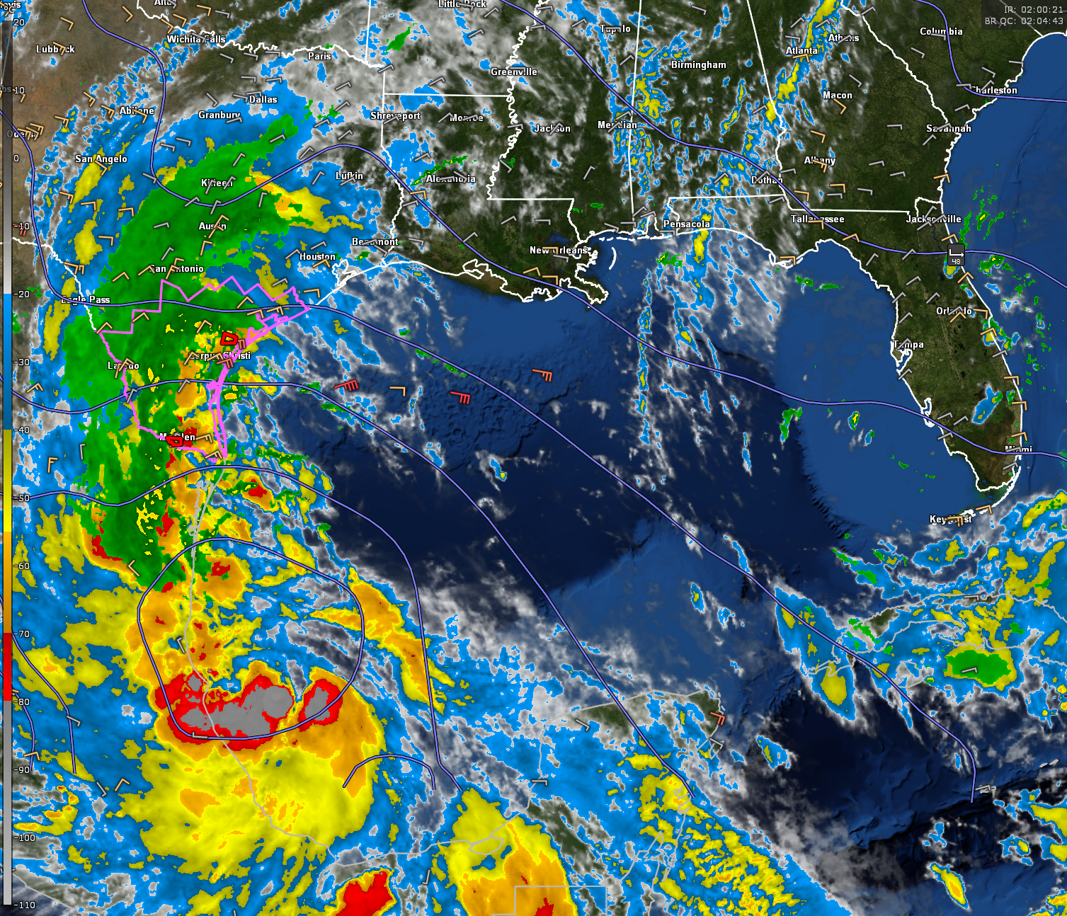
IN THE TROPICS: Tropical Storm Alberto finally got its act together enough to become an official tropical cyclone yesterday. The lumbering, wet and windy cyclone moved into northeastern Mexico early this morning. The effects were felt far to the north, with tropical storm force winds, very heavy rains, coastal flooding and tornadoes felt well into Texas. A tornado caused damage near Rockport, Texas Wednesday evening. A tornado watch and several tornado warnings were in effect.
NEXT UP TROPICALLY: The NHC is getting more bullish on the idea that a second tropical cyclone will form over the southeastern Caribbean in coming days, an idea that is supported by the global models.
THIRD SYSTEM: The NHC is still tracking the disturbance east of the Bahamas. They put the chances of development as very small. It appears that the low pressure system will come ashore Friday afternoon between Jacksonville and Savannah Friday afternoon. But the primary impacts will be wind gusts to about 30 mph and scattered showers. No biggie.
WEATHERBRAINS: Next week, the panel will entertain meteorologist Cameron Nixon. Check out the show at www.WeatherBrains.com. You can also subscribe on iTunes. You can watch the show live on our new YouTube channel for the show.You will be able to see the show on the James Spann 24×7 weather channel on cable or directly over the air on the dot 2 feed.
ON THIS DATE IN 2001: A major hailstorm pounded Denver International Airport, damaging 93 commercial planes and causing the cancellation of hundreds of flights over the next several days. There were two minor inujuries. Over 14,000 holes and cracks were punched in the flat roofs of the terminal buildings by the hail that was up to 2 inches in diameter. Over 4000 automobiles received hail damage. An hour later, 30 private planes were damaged by large hail up to 2/5 inches in diameter at Front Range Airport in Watkins CO. $49 million in damage in the Watkins area and $10 million to the DIA facilities along, not including the airliners. Follow my weather history tweets on Twitter. I am @wxhistorian at Twitter.com.
Category: Alabama's Weather, ALL POSTS, Tropical
About the Author (Author Profile)
Bill Murray is the President of The Weather Factory. He is the site's official weather historian and a weekend forecaster. He also anchors the site's severe weather coverage. Bill Murray is the proud holder of National Weather Association Digital Seal #0001 @wxhistorianSubscribe
If you enjoyed this article, subscribe to receive more just like it.


