

Midday Nowcast: Great Weather for Juneteenth; Tropical Storm Alberto Forms
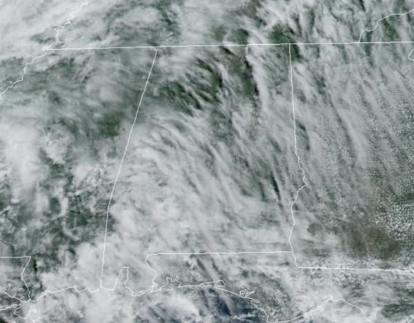
HAPPY JUNETEENTH: Little change in the forecast the next few days; the days are featuring a mix of sun and clouds and rain chances are less than 10% and a stray pop-up shower or two cannot be ruled out as a dry easterly flow is in place across the state. Afternoon highs are around 90° today, but tomorrow and Friday temperatures will be in the mid-90s for most of North/Central Alabama.
BIRMINGHAM ALMANAC: For June 18th, the average high for Birmingham is 89° and the average low is 69°. The record high is 101° set in 1936, while the record low is 54° set in 1965. We average 0.16” of precipitation on this date, and the record value is 4.36” set in 2021.
HOT ALABAMA WEEKEND: Heat levels continue to rise with highs in the mid and upper 90s by Saturday and Sunday. Moisture levels will begin to rise Saturday and Sunday and we will begin to increase the chance for widely scattered afternoon showers and storms both days.
NEXT WEEK: Moisture levels continue to rise Monday and Tuesday with showers and storms increasing in number, along with lower heat levels. The rest of next week looks to be fairly routine for late June.
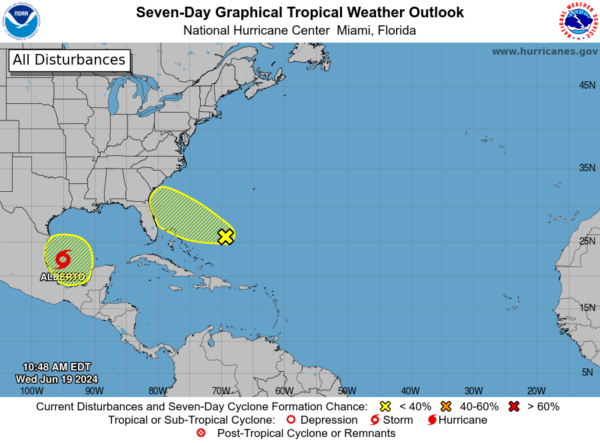
IN THE TROPICS: Three areas the National Hurricane Center is monitoring, and we now have Tropical Storm Alberto.
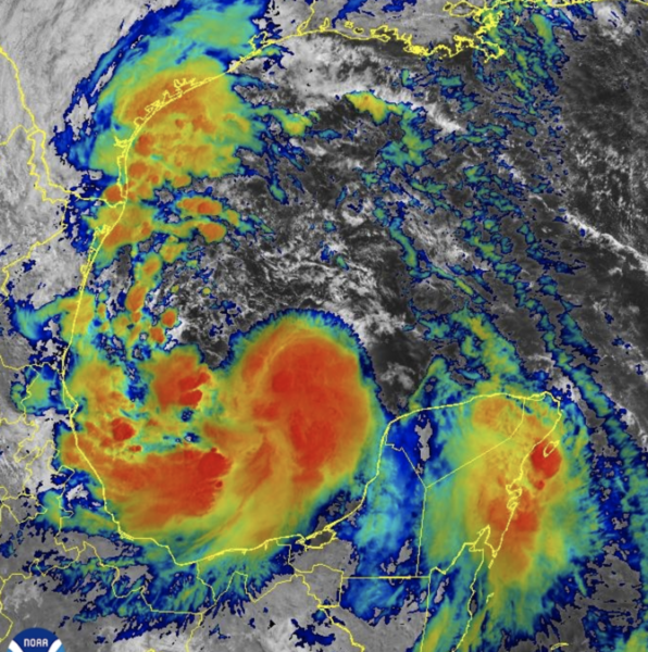
At 1000 AM CDT, the center of Tropical Storm Alberto was located near latitude 22.2 North, longitude 95.0 West. Alberto is moving toward the west near 9 mph. A westward motion with an increase in forward speed is expected through Thursday. On the forecast track, the center of Alberto will reach the coast of northeastern Mexico early Thursday morning.
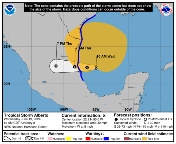
Maximum sustained winds are near 40 mph with higher gusts. Some slight strengthening is forecast today or tonight before the center of Alberto reaches land. Rapid weakening is expected once the center moves inland, and Alberto is likely to dissipate over Mexico Thursday or Thursday night.
Alberto is a large tropical storm, with tropical-storm-force winds extending outward up to 415 miles north of the center. The minimum central pressure based on dropsonde data is 995 mb (29.39 inches).
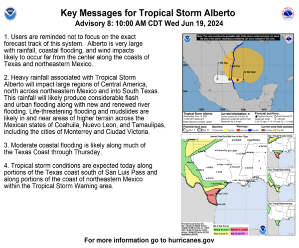
Elsewhere, in the Atlantic, an area of showers and thunderstorms located several hundred miles east of the Bahamas is associated with a surface trough of low pressure. Environmental conditions are marginally conducive for some gradual development of this system during the next few days while it moves westward or west-northwestward. The system is forecast to approach the coast of the southeastern United States by the latter part of this week. Formation chance through 7 days…low…20 percent.
Also, in the Southwestern Gulf of Mexico, another broad area of low pressure is forecast to develop over the southwestern Gulf of Mexico this weekend. Environmental conditions are expected to be conducive for gradual development of this system through early next week while it moves slowly west-northwestward or northwestward. Formation chance through 7 days…low…30 percent.
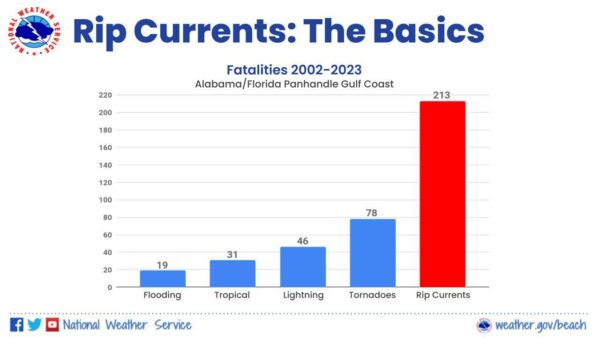
BEACH FORECAST CENTER: Dangerous surf conditions with large breaking waves and strong rip currents will continue for the next few days along the Alabama coast and the western Florida panhandle beaches. Many area beaches are reporting double red flags again today, meaning the water is closed to the public.
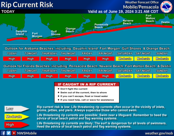
Please pay attention to the flag warning system along the Northern Gulf Coast beaches as rip currents are the number one weather killer for the NWS offices in Mobile and Tallahassee which cover those beautiful white sand beaches so many of us enjoy from Mexico Beach to Panama City to Destin to Pensacola to Orange Beach to Gulf Shores to Fort Morgan and Dauphin Island.
Get the latest weather and rip current forecasts for the beaches from Fort Morgan to Panama City on our Beach Forecast Center page. There, you can select the forecast of the region that you are interested in visiting.
WORLD TEMPERATURE EXTREMES: Over the last 24 hours, the highest observation outside the U.S. was 123.3F at Nasiriya, Iraq. The lowest observation was -104.1F at Concordia, Antarctica.
CONTIGUOUS TEMPERATURE EXTREMES: Over the last 24 hours, the highest observation was 112F at Rio Grande Village, TX. The lowest observation was 15F at Mackay, ID.
Category: Alabama's Weather, ALL POSTS
About the Author (Author Profile)
Macon, Georgia Television Chief Meteorologist, Birmingham native, and long time Contributor on AlabamaWX. Stormchaser. I did not choose Weather, it chose Me. College Football Fanatic. @Ryan_StinnetSubscribe
If you enjoyed this article, subscribe to receive more just like it.


