

Tropical Storm Alberto Forms
…TROPICAL STORM ALBERTO FORMS OVER THE WESTERN GULF OF MEXICO…
…HEAVY RAINS, COASTAL FLOODING, AND GUSTY WINDS FORECAST ALONG
THE COASTS OF TEXAS AND NORTHEASTERN MEXICO THROUGH THURSDAY…
SUMMARY OF 1000 AM CDT…1500 UTC…INFORMATION
———————————————–
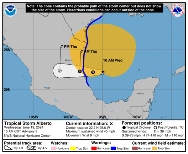
LOCATION…22.2N 95.0W
ABOUT 185 MI…300 KM E OF TAMPICO MEXICO
ABOUT 295 MI…480 KM SSE OF BROWNSVILLE TEXAS
MAXIMUM SUSTAINED WINDS…40 MPH…65 KM/H
PRESENT MOVEMENT…W OR 270 DEGREES AT 9 MPH…15 KM/H
MINIMUM CENTRAL PRESSURE…995 MB…29.39 INCHES
WATCHES AND WARNINGS
——————–
CHANGES WITH THIS ADVISORY:
The government of Mexico has extended the Tropical Storm Warning
southward to Tecolutla.
SUMMARY OF WATCHES AND WARNINGS IN EFFECT:
A Tropical Storm Warning is in effect for…
* the Texas coast from San Luis Pass southward to the mouth of the
Rio Grande
* the northeastern coast of Mexico south of the mouth of the Rio
Grande to Tecolutla.
A Tropical Storm Warning means that tropical storm conditions are
expected somewhere within the warning area.
For storm information specific to your area in the United States,
including possible inland watches and warnings, please monitor
products issued by your local National Weather Service forecast
office. For storm information specific to your area outside of the
United States, please monitor products issued by your national
meteorological service.
DISCUSSION AND OUTLOOK
———————-
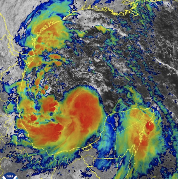
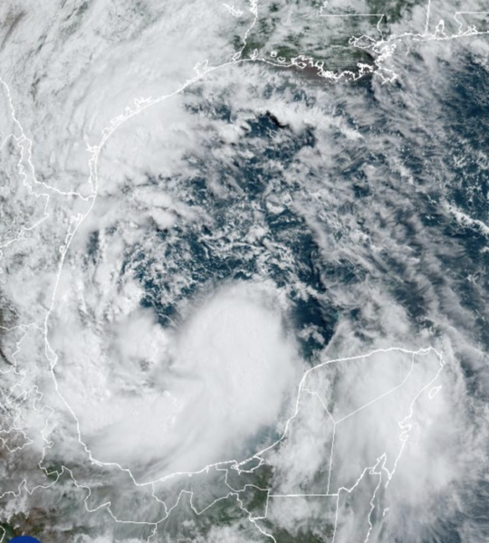
At 1000 AM CDT (1500 UTC), the center of Tropical Storm Alberto was
located near latitude 22.2 North, longitude 95.0 West. Alberto is
moving toward the west near 9 mph (15 km/h). A westward motion
with an increase in forward speed is expected through Thursday. On
the forecast track, the center of Alberto will reach the coast of
northeastern Mexico early Thursday morning.
Maximum sustained winds are near 40 mph (65 km/h) with higher gusts.
Some slight strengthening is forecast today or tonight before the
center of Alberto reaches land. Rapid weakening is expected once
the center moves inland, and Alberto is likely to dissipate over
Mexico Thursday or Thursday night.
Alberto is a large tropical storm, with tropical-storm-force winds
extending outward up to 415 miles (665 km) north of the center.
The minimum central pressure based on dropsonde data is 995 mb
(29.39 inches).
HAZARDS AFFECTING LAND
———————-
Key messages for Alberto can be found in the Tropical Cyclone
Discussion under AWIPS header MIATCDAT1 and WMO header WTNT41 KNHC.
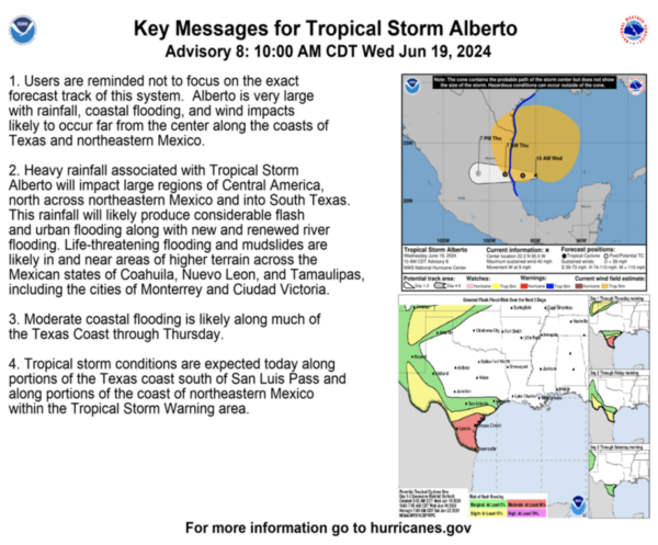
RAINFALL: Tropical Storm Alberto is expected to produce rainfall
totals of 5 to 10 inches across northeast Mexico into South Texas.
Maximum totals around 20 inches are possible across the higher
terrain of the Mexican states of Coahuila, Nuevo Leon, and
Tamaulipas. This rainfall will likely produce considerable flash and
urban flooding along with new and renewed river flooding. Mudslides
are also possible in areas of higher terrain across northeast
Mexico.
For a complete depiction of forecast rainfall and flash flooding
associated with Alberto, please see the National Weather Service
Storm Total Rainfall Graphic, available at
hurricanes.gov/graphics_at1.shtml?rainqpf and the Flash Flood Risk
graphic at hurricanes.gov/graphics_at1.shtml?ero
STORM SURGE: The combination of a dangerous storm surge and
the tide will cause normally dry areas near the coast to be flooded
by rising waters moving inland from the shoreline. The water could
reach the following heights above ground somewhere in the indicated
areas if the peak surge occurs at the time of high tide…
Sargent, TX to Sabine Pass, TX…2-4 ft
Galveston Bay…2-4 ft
Mouth of the Rio Grande, TX to Sargent, TX…1-3 ft
Sabine Pass, TX to Vermilion/Cameron Parish Line, LA…1-3 ft
The deepest water will occur along the immediate coast near and to
the north of the landfall location, where the surge will be
accompanied by large and dangerous waves. Surge-related flooding
depends on the relative timing of the surge and the tidal cycle,
and can vary greatly over short distances. For information
specific to your area, please see products issued by your local
National Weather Service forecast office.
For a complete depiction of areas at risk of storm surge inundation,
please see the National Weather Service Peak Storm Surge Graphic,
available at hurricanes.gov/graphics_at1.shtml?peakSurge.
Storm surge will raise water levels by as much as 1 to 3 feet above
normal tide levels along the immediate coast of northeastern
Mexico in areas of onshore winds north of where the center makes
landfall. Near the coast, the surge will be accompanied by large
and destructive waves.
WIND: Tropical storm conditions are expected within the warning
area today through early Thursday.
TORNADOES: A couple of tornadoes are possible today and tonight
across parts of Deep South Texas and Southeast Texas.
SURF: Swells generated by Alberto will affect the coast of Texas
and northeastern Mexico through Friday. These swells are
likely to cause life-threatening surf and rip current conditions.
Please consult products from your local weather office.
About the Author (Author Profile)
Macon, Georgia Television Chief Meteorologist, Birmingham native, and long time Contributor on AlabamaWX. Stormchaser. I did not choose Weather, it chose Me. College Football Fanatic. @Ryan_StinnetSubscribe
If you enjoyed this article, subscribe to receive more just like it.


