

May Mix Of Sun And Showers Through The Weekend
RADAR CHECK: Scattered showers and a few thunderstorms are active this morning; some of the heaviest rain is falling over the northwest counties of the state along with other parts of the Tennessee Valley. Otherwise the sky is mostly cloudy with temperatures in the 60s and 70s.
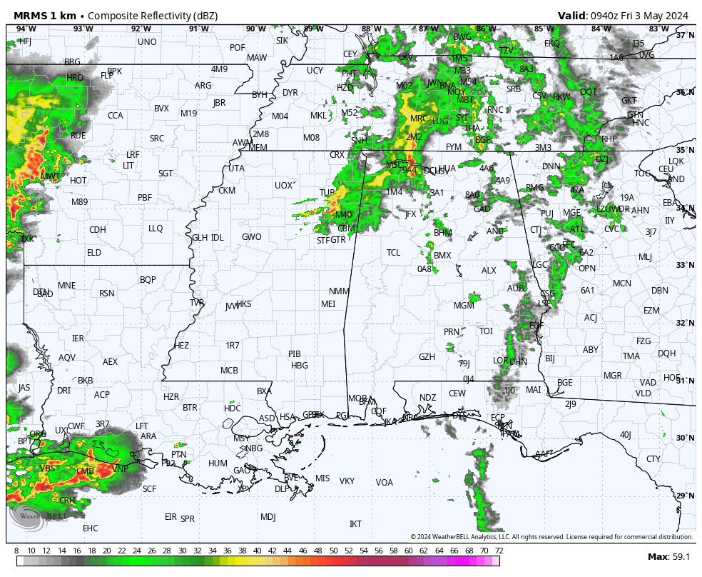
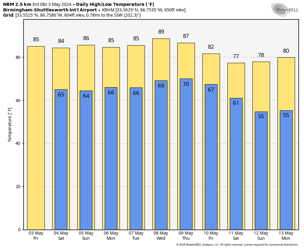
Look for intervals of sun today with scattered showers; high resolution model output suggests the highest coverage of rain will come this morning, with showers more widely spaced this afternoon. The high today will be in the mid 80s.
THE ALABAMA WEEKEND: Not much change in the weather. It will be a mixed bag with periods of sun along with random, scattered showers tomorrow and Sunday. Not as wash-out at all, but you will see some rain from time to time. Higher rain probabilities will remain over the northern half of the state. Some thunder is possible, but there is no risk of severe storms. Afternoons will stay warm with highs in the mid 80s.
NEXT WEEK: A few widely scattered showers will remain possible pretty much on a daily basis through the week, otherwise partly sunny days with highs in the mid to upper 80s. A cold front will likely bring a higher cover coverage of showers and thunderstorms toward the end of the week on Friday… See the video briefing for maps, graphics, and more details.
ON THIS DATE IN 1999: There were 63 tornadoes in Oklahoma, making this the worst outbreak ever to strike the state. In Central Oklahoma alone, eight individual supercell thunderstorms produced 57 tornadoes. Bridge Creek, Moore and southern parts of the Oklahoma City Metro area were hit the hardest. When it was near Moore, Oklahoma, a truck-mounted Doppler radar measured a wind speed of 318 mph, the highest ever observed in a tornado.
Forecasters at the Storm Prediction Center in Norman, OK were faced with the unprecedented situation of a major tornado on the ground threatening their location. As a major F5 tornado was approaching the Oklahoma City metro area from the southwest, the SPC notified its backup, the Air Force Weather Agency at Offutt AFB in Omaha, Nebraska that they might have to assume operational responsibility if the tornado approached Norman. The storm remained several miles west of the facility but was visible from the SPC roof. Damage from this single tornado was around one billion dollars, making it the most costly tornado in history.
To the north in Kansas, an F4 tornado tracked 24 miles through Sumner and Sedgwick Counties, killing 6, injuring 154, and causing $146 million in damages.
ON THIS DATE IN 2009: A derecho moved across Central Alabama on Sunday afternoon. A derecho is a widespread and long-lived straight line wind storm associated with a fast moving squall line. A derecho can produce a long-lived gust front which causes straight line wind damage with winds over 58 mph. The derecho on Sunday produced damage in several counties from the Mississippi state line to the Georgia state line. In addition, five tornadoes touched down across the state.
Look for the next video briefing here by 3:00 this afternoon… enjoy the day!
Category: Alabama's Weather, ALL POSTS, Weather Xtreme Videos
About the Author (Author Profile)
James Spann is one of the most recognized and trusted television meteorologists in the industry. He holds the AMS CCM designation and television seals from the AMS and NWA. He is a past winner of the Broadcast Meteorologist of the Year from both professional organizations.Subscribe
If you enjoyed this article, subscribe to receive more just like it.


