

Midday Nowcast: Front Dropping South
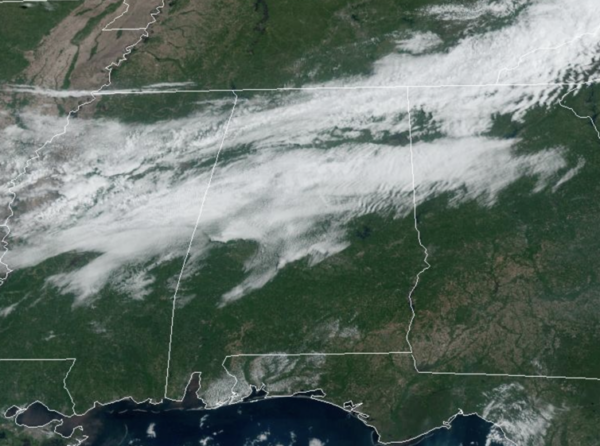
A weak cold front continues to drop south through Alabama today, bringing more clouds in the sky. However, with very limited moisture, we are not expecting anything but small, isolated showers through the afternoon and evening hours. Rain chances are less than 10%. Otherwise, the sky is partly to mostly sunny with afternoon temperatures climbing into the upper 70s for most locations across North and Central Alabama.
BIRMINGHAM ALMANAC: For April 22nd, the average high for Birmingham is 77° and the average low is 55°. The record high is 90° set in 1925, while the record low is 35° set in 1986. We average 0.16” of precipitation on this date, and the record value is 3.08” set in 2010.
ACROSS THE USA: A few isolated severe thunderstorms may develop across portions of the southern High Plains and Lower Mississippi Valley this afternoon through this evening. The combination of dry conditions and gusty winds will lead to elevated to critical fire weather conditions across New Mexico and southern Colorado through the weekend.
TOMORROW THROUGH THE WEEKEND: The front basically dissipates across the state tomorrow, but still a few isolated showers can’t be ruled out, but most communities will stay dry with a high in the low 80s. The weather stays warm and generally dry Friday through the weekend with partly sunny days and highs in the low to mid 80s. Rain chances are not zero through the weekend, but generally less than 10% any given day.
NEXT WEEK: A weakening front will bring the chance of showers to Alabama Monday, and possibly Tuesday, but severe storms are not expected with the main dynamic support passing far to the north. The weather looks dry Wednesday through Friday and the week will be warm with highs in the 80s. Still no sign of any high impact weather event (flooding, severe storms, etc) for Alabama for the next seven to ten days.
BEACH FORECAST CENTER: Get the latest weather and rip current forecasts for the beaches from Fort Morgan to Panama City on our Beach Forecast Center page. There, you can select the forecast of the region that you are interested in visiting.
WORLD TEMPERATURE EXTREMES: Over the last 24 hours, the highest observation outside the U.S. was 115.2F at Chauk, Myanmar. The lowest observation was -96.9F at Vostok, Antarctica.
CONTIGUOUS TEMPERATURE EXTREMES: Over the last 24 hours, the highest observation was 99F at Gila Bend, AZ and Death Valley, CA. The lowest observation was 15F at Forest Center, MN.
Category: Alabama's Weather, ALL POSTS
About the Author (Author Profile)
Macon, Georgia Television Chief Meteorologist, Birmingham native, and long time Contributor on AlabamaWX. Stormchaser. I did not choose Weather, it chose Me. College Football Fanatic. @Ryan_StinnetSubscribe
If you enjoyed this article, subscribe to receive more just like it.


