

Midday Nowcast: Sunshine in Full Supply
MARVELOUS MONDAY: It is a beautiful, sunny day across Alabama, and after the chilly start to the day, temperatures are rising into the upper 60s and lower 70s this afternoon, which are 5-10 degrees below average for this time of year. Tonight will be clear and chilly with lows in the upper 30s and lower 40s, and there could be some patchy frost in those colder spots.
BIRMINGHAM ALMANAC: For April 22nd, the average high for Birmingham is 77° and the average low is 54°. The record high is 90° set in 1987, while the record low is 31° set in 1993. We average 0.16” of precipitation on this date, and the record value is 1.97” set in 1909.
ACROSS THE USA: Dry conditions and gusty winds will contribute to critical fire weather across parts of Colorado, Wyoming, Montana, Guam, and the Dakotas today. A cold front crossing the Great Lakes will bring periods of rain showers and some higher elevation snow showers to the Midwest, Great Lakes, Ohio Valley, and Northeast Tuesday into Wednesday.
TOMORROW/WEDNESDAY: Sunshine rules the day again tomorrow and temperatures will surge into the mid and upper 70s. Tomorrow night will be cool with lows in the lower 50s. Wednesday will again feature more sunshine than clouds with mid to upper 70s for afternoon highs.
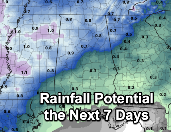
THURSDAY THROUGH THE WEEKEND: We will mention the chance of a few widely scattered showers Thursday, otherwise the weather will likely stay dry through the weekend with a warming trend continuing. The high Thursday will be in the upper 70s, followed by low to mid 80s statewide Friday through Sunday. An upper ridge will keep the big storm producing systems well to the west and north of Alabama. Rainfall potential the next seven days is light at best for Alabama with totals less than an inch state wide.
NEXT WEEK: A relatively quiet pattern continues. Showers are possible across Alabama on Tuesday but the rest of the week looks warm and dry with highs in the 80s. Still no sign of any high impact weather event for our state (flooding, severe storms) for the next 7-10 days.
BEACH FORECAST CENTER: Get the latest weather and rip current forecasts for the beaches from Fort Morgan to Panama City on our Beach Forecast Center page. There, you can select the forecast of the region that you are interested in visiting.
WORLD TEMPERATURE EXTREMES: Over the last 24 hours, the highest observation outside the U.S. was 113.4F at Ndjamena, Chad. The lowest observation was -102.6F at Concordia, Antarctica.
CONTIGUOUS TEMPERATURE EXTREMES: Over the last 24 hours, the highest observation was 103F at Stovepipe Wells and Death Valley, CA. The lowest observation was 9F at Peter Sinks, UT and Foxpark, WY.
Category: Alabama's Weather, ALL POSTS
About the Author (Author Profile)
Macon, Georgia Television Chief Meteorologist, Birmingham native, and long time Contributor on AlabamaWX. Stormchaser. I did not choose Weather, it chose Me. College Football Fanatic. @Ryan_StinnetSubscribe
If you enjoyed this article, subscribe to receive more just like it.


