

Wet,Unsettled Weather For Alabama This Week
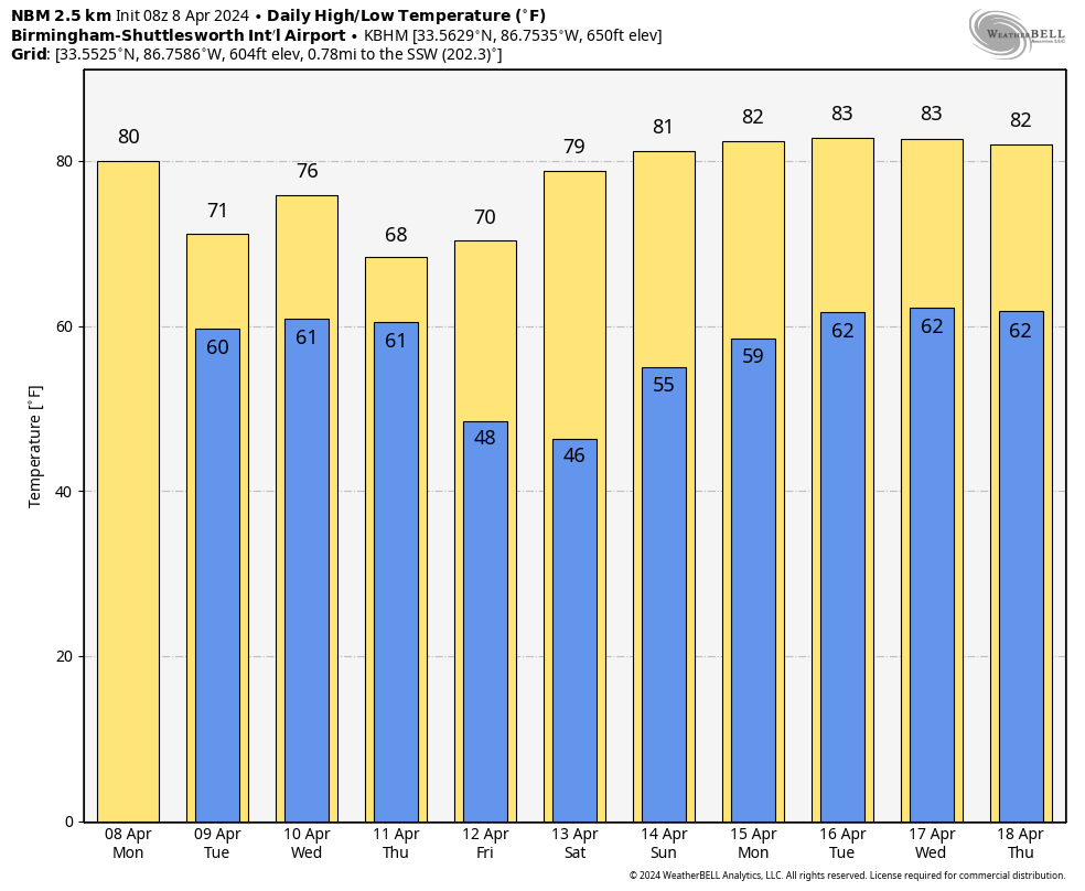
RADAR CHECK: A few showers and thunderstorms are over the Tennessee Valley of far North Alabama early this morning, otherwise the sky is mostly cloudy with temperatures in the 50s and 60s. Expect more clouds than sun today with a chance of showers, mainly for the northern and western part of Alabama. Temperatures will peak around 80 degrees this afternoon.
Rain and thunderstorms will become more widespread tomorrow over the northern half of the state, and statewide on Wednesday. The rain will be heavy at times Wednesday and Wednesday night; rain amounts between now and early Friday will be in the 2-4 inch range for much of the state. Some flooding issues are possible.
Also, a few storms could be strong to severe Wednesday as a surface low passes northwest of the state. SPC has an “enhanced risk” (level 3/5) of severe thunderstorms in place Wednesday across Southwest Alabama in the broad zone from York to Mobile. A “slight risk” (level 2/5) extends as far north as Haleyville, Birmingham, and Auburn, and the rest of the state is in a “marginal risk” (level 1/5).
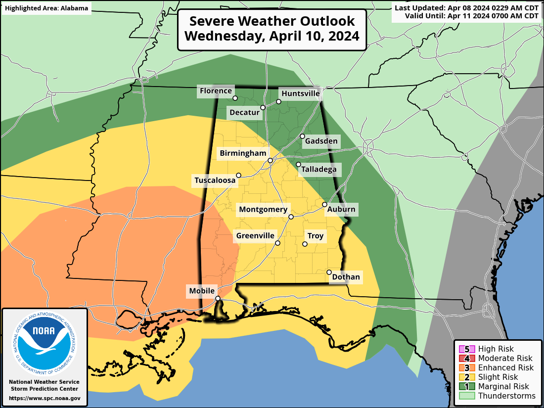
Thankfully the air should be generally rain cooled and stable; the main issue will come from strong, gusty winds. However, an isolated tornado can’t be ruled out, mainly in the “enhanced risk” area.
Thursday will be a mostly cloudy, cooler day with some risk of lingering showers over the northern half of the state.
FRIDAY AND THE WEEKEND: Friday will be a partly to mostly sunny day with a high around 70 degrees. Then, the weekend will be warm and dry with lots of sun Saturday and Sunday along with afternoon highs around 80 degrees.
NEXT WEEK: It looks like much of the week will stay warm and dry with highs exceeding 80 degrees on a daily basis. Some rain is possible toward the end of the week… See the video briefing for maps, graphics, and more details.
TODAY’S SOLAR ECLIPSE: The path of totality is north and west of Alabama; here it will be a partial eclipse. A few notes…
*For Alabama, it will begin around 12:45, peaking at 2:00. The eclipse is over around 3:15
*Clouds will be thin enough over much of Alabama to see it, thicker clouds will likely be over the northern third of the state (north of Birmingham). Best chance of a mostly clear sky is over East and Southeast Alabama.
*For most of Alabama, about 80-90 percent of the sun will be blocked during the peak.
*However, the sky will still be bright, and most that are outside won’t notice much difference. You need to be in the path of totality for the main effect.
*If you choose to look at the sun (during the eclipse, or anytime), always wear the proper safety glasses (ISO 12312-2).
ON THIS DATE IN 1998: An F-5 tornado cut a 31-mile long, 3/4-mile wide swath through nine Birmingham suburbs including Oak Grove, Sylvan Springs, Rock Creek, Pleasant Grove, Concord, Maytown, Pratt City, and Edgewater before lifting in the western limits of the City of Birmingham. The worst of the destruction occurred across the Oak Grove, Rock Creek and McDonald Chapel areas.
Thirty-two people were killed in this tornado including three in Oak Grove, eleven near Rock Creek, four in Sylvan Springs, two in Wylam Heights, nine in Edgewater, two in McDonald Chapel and one in West Ensley. The same parent storm would drop another tornado that killed two more people in St. Clair County near Wattsville.
Look for the next video briefing here by 3:00 this afternoon… enjoy the day!
Category: Alabama's Weather, ALL POSTS, Weather Xtreme Videos
About the Author (Author Profile)
James Spann is one of the most recognized and trusted television meteorologists in the industry. He holds the AMS CCM designation and television seals from the AMS and NWA. He is a past winner of the Broadcast Meteorologist of the Year from both professional organizations.Subscribe
If you enjoyed this article, subscribe to receive more just like it.


