Alabama 811 | Know What's Below.

Archive for April 14th, 2012

Good News From Wichita

Good News From Wichita

| April 14, 2012 @ 11:54 pm

From Sedgwick County Emergency Management concerning the tornado that passed across the Wichita Metro tonight: We will have significant damage across south and east Sedgwick County; numerous buildings suffered partial collapse or worse. We still are trying to get a handle on situational awareness as far as building damage. So far, injury reports are few […]

Read More

Two Tornadic Supercells in Kansas

Two Tornadic Supercells in Kansas

| April 14, 2012 @ 11:01 pm

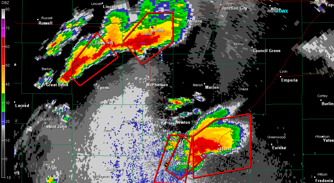
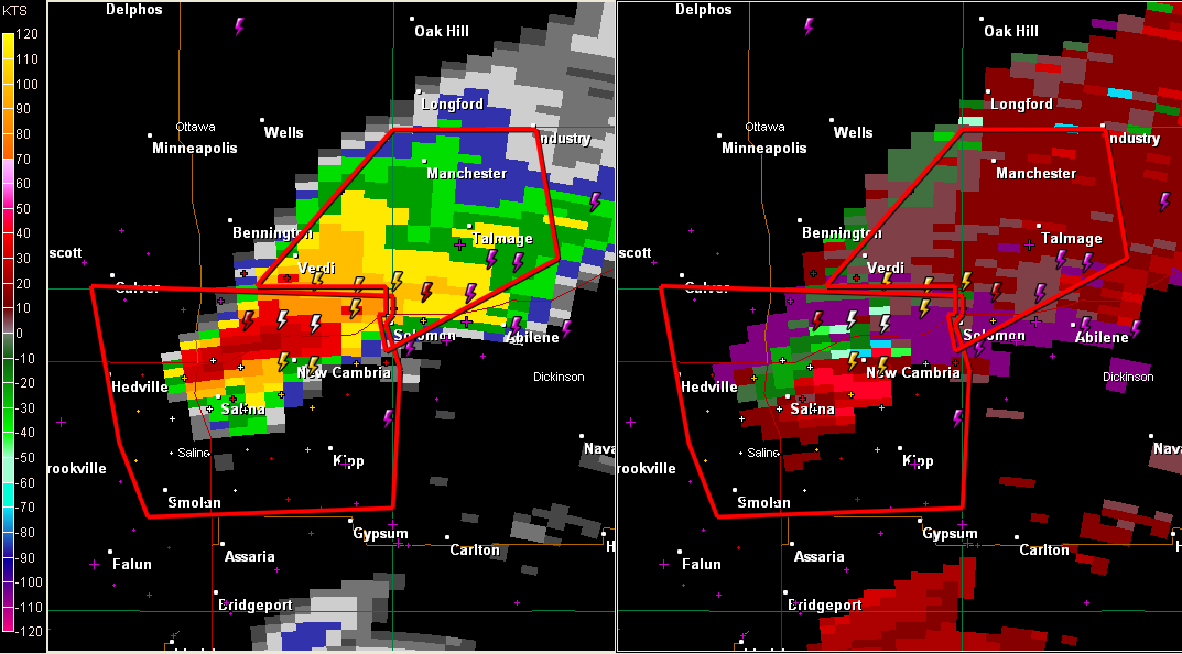
In this radar image, you can see the storm producing the tornado that struck Wichita approaching El Dorado. To the northwest, a thunderstorm producing a confirmed tornado that is on the ground is south of Salina. MOBILE HOME PARK HIT We have reports that a mobile home park near Oaklawn on the southern side of […]

Read More

Tornado Passing Andover KS, Another Heading Toward Salina

Tornado Passing Andover KS, Another Heading Toward Salina

| April 14, 2012 @ 10:41 pm

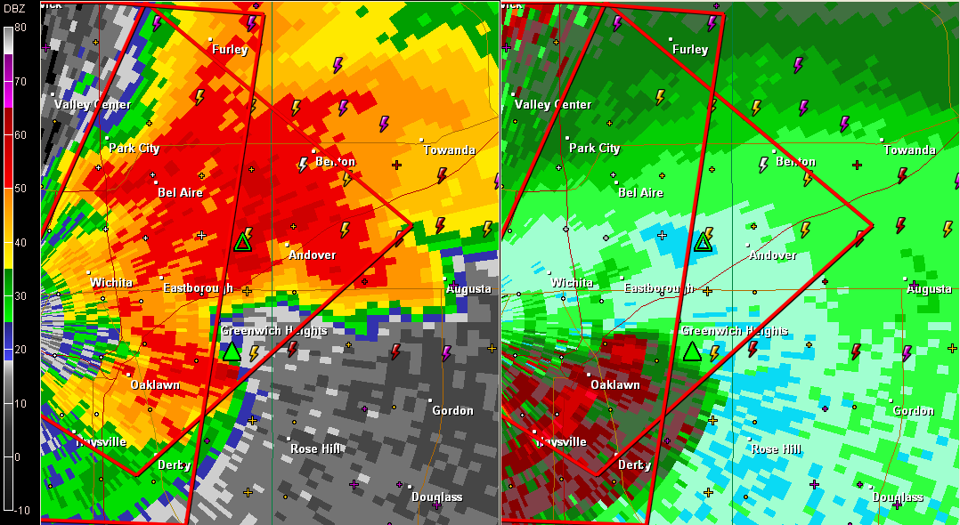
Tornado was visible at 10:36 p.m. near McConnell AFB. The tornado has crossed the southern part of Wichita and is moving through eastern Wichita metro now. Another large and extremely dangerous tornado is moving toward Salina now. The two largest cities in the Wichita DMA are being threatened right now.

Read More

Tornado Emergency for WIchita

Tornado Emergency for WIchita

| April 14, 2012 @ 10:29 pm

Catastrophic tornado warning for Wichita. It is very near McConnell AFB. Tracking along I-35, the Kansas Turnpike. Will pass near Andover. Andover is infamous from the 1991 violent tornado that hit that community. LATE REPORT 1 S South Wichita [Sedgwick Co, KS] trained spotter reports TORNADO at 10:29 PM CDT — 55th and broadway,tornado on […]

Read More

Tornado Moving into Wichita, NWS Evacuates

Tornado Moving into Wichita, NWS Evacuates

| April 14, 2012 @ 10:11 pm

LATE REPORT: from Tim Marquis (via spotternetwork.org) @ 10:15 PM CDT — (S) Tor — — Spotter is 3 miles SE of Peck, KS (Sumner county) [37.449/-97.332] — Large wedge tornado approximately 3 miles to my north. (SN#1117 10:16 ANOTHER Tyler Costantini (via spotternetwork.org) @ 10:15 PM CDT — (S) Other — — Spotter is […]

Read More

NWS WIchita About To Go Into Shelter

NWS WIchita About To Go Into Shelter

| April 14, 2012 @ 10:00 pm

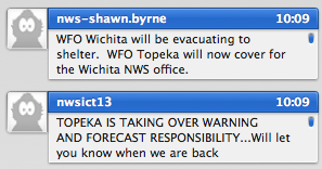
Starting to get reports of damage from Sumner County, southwest of Wichita,including homes destroyed. The tornado will pass very near the NWS Wichita office. They are about to go into shelter. *CORRECTION* Topeka Tulsa will take over for them. Here is a very compelling message from the NWS Wichita. 000 WWUS53 KICT 150254 RRA SVSICT […]

Read More

Dangerous Situation for Wichita

Dangerous Situation for Wichita

| April 14, 2012 @ 9:39 pm

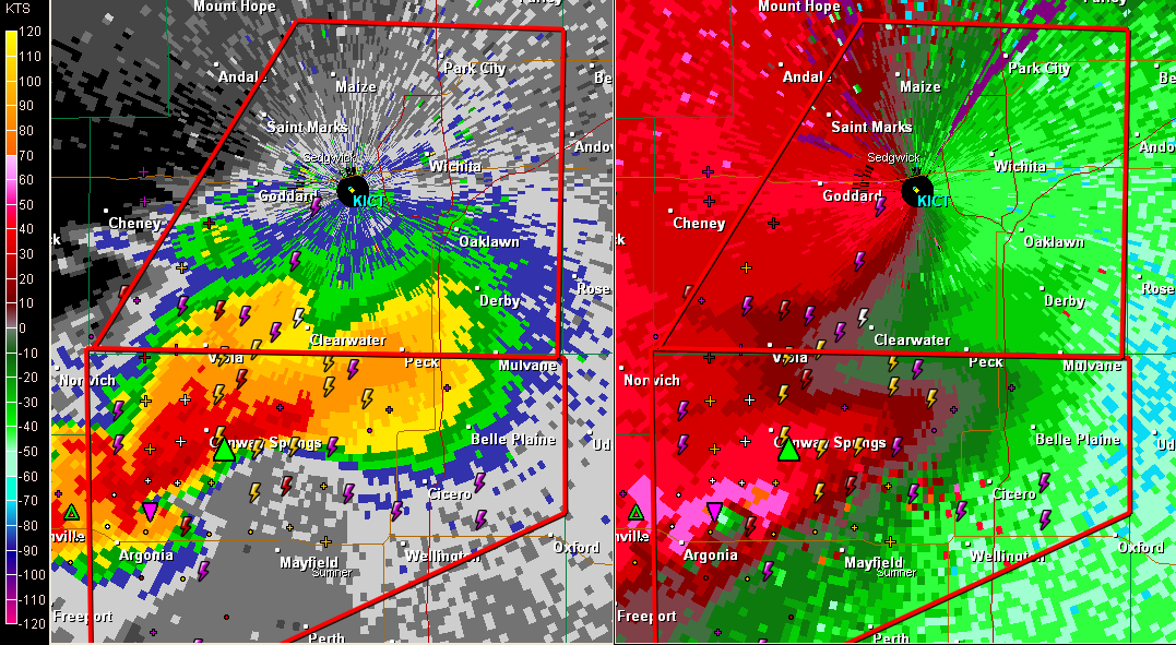
The NWS has issued a tornado warning for Sedgwick County, KS, including the City of Wichita. The large wedge tornado is now over Harper County south of Conway Springs. It has passed Argonia. The power is out in Argonia. Numerous spotters, chasers and law enforcement representatives are on the tornado. If you are reading this […]

Read More

“Very, Very Large Wedge Tornado” in Kansas

“Very, Very Large Wedge Tornado” in Kansas

| April 14, 2012 @ 9:01 pm

“Very, very large wedge tornado” crossed the OK/KS border into Kansas a short time ago. Late report at 9 p.m. says a half mile wide tornado is definitely on the ground. Here is the radar: It shows a TVS, very large hail of at least two inches, a storm top over 55 thousand feet and […]

Read More

Our Attention Turns to Wichita

Our Attention Turns to Wichita

| April 14, 2012 @ 8:35 pm

We have been tracking a long lived cyclic supercell in northern Oklahoma for well over an hour. Val Castor says it is a large tornado on the ground. It is now just west of Amorita OK. It will pass into Harper County KS shortly where a tornado warning is in effect. If this storm holds […]

Read More

Huge Torndado South of Cherokee OK

Huge Torndado South of Cherokee OK

| April 14, 2012 @ 8:01 pm

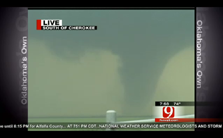
Channel 9 in OKC tracking huge tornado west southwest of Cherokee in northern Oklahoma. It is moving moving toward Cherokee and Ingersoll. Violent rotation indicated on radar. Now two tornadoes on the ground with this storm.

Read More

Gary England Following Tornado Near Waynoka OK

Gary England Following Tornado Near Waynoka OK

| April 14, 2012 @ 7:24 pm

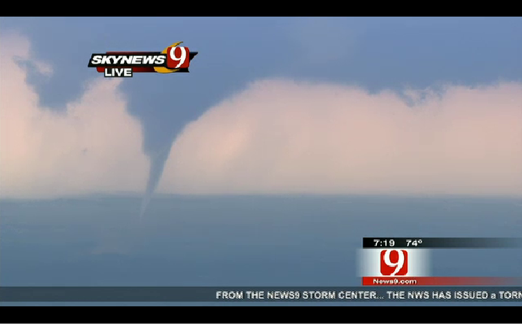
Large tornado captured on the ground near Waynoka OK on Channel 9. This capture was taken when it had gotten smaller. And it has since lifted, but the wall cloud is lowering again. See their streaming here: https://www.news9.com/weather This is near Alva, west of Ponca City in northern Oklahoma. It or lightning hit an oil […]

Read More

Classic Flying Eagle Radar Signature

Classic Flying Eagle Radar Signature

| April 14, 2012 @ 7:09 pm

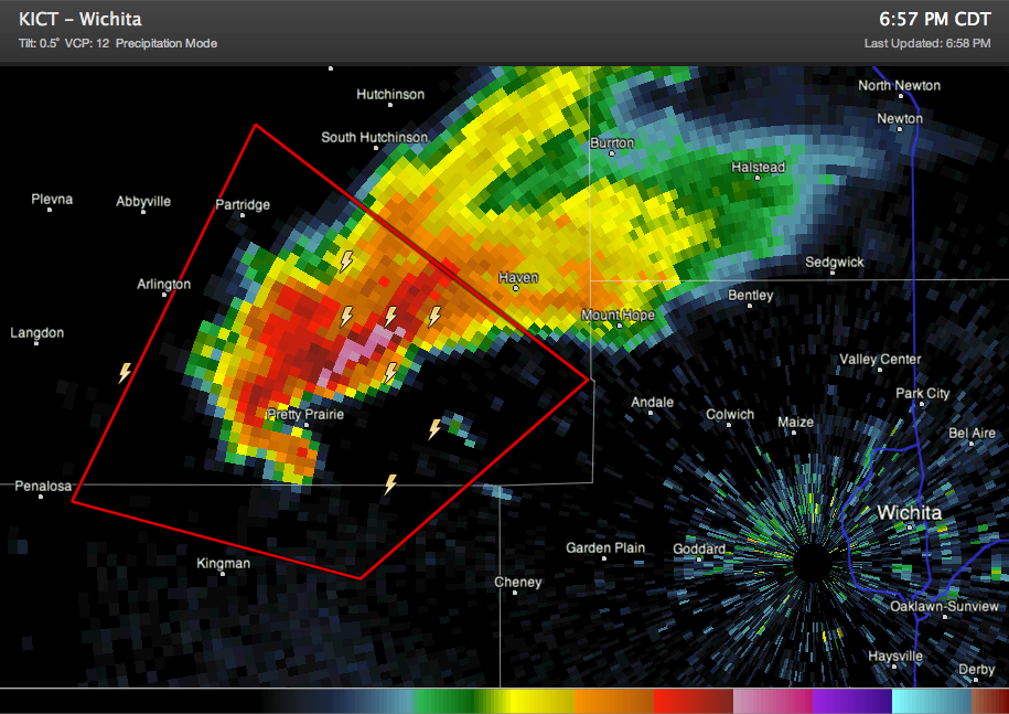
Another tornado on the ground in Kansas. This one closer to Wichita and threatening Hutchinson. It shows the classic “flying eagle” radar signature. Imagine the “wings” coming out to the northeast, the head in highest reflectivity just northeast of Pretty Prairie, where large hail is falling and the tail is the hook echo. It indicates […]

Read More

Tornado Miraculously Skips Over Salina, Back on the Ground

Tornado Miraculously Skips Over Salina, Back on the Ground

| April 14, 2012 @ 6:55 pm

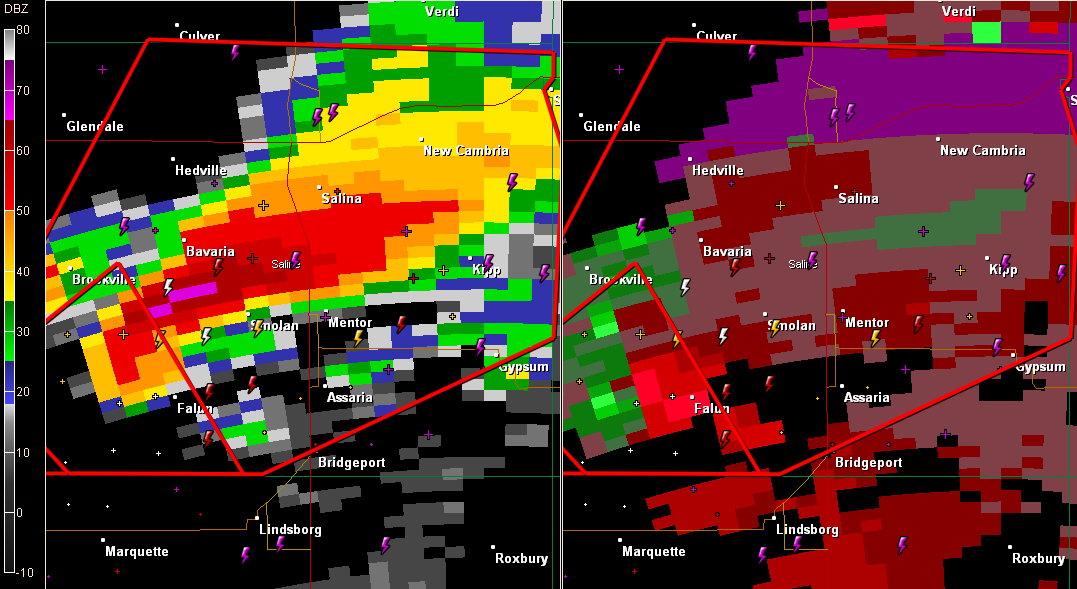
The tornado we have been tracking aparently lifted before hitting Salina KS. But it is back on the ground near New Cambria. The next town in its path is Solomon. It is about to cross I-70.

Read More

Tornado Threatening Salina KS

Tornado Threatening Salina KS

| April 14, 2012 @ 6:24 pm

LATE REPORT at 6:38: Spotters indicate the tornado coming into the heart of Salina KS has lifted. It may still touch down at any time and everyone in Salina should be in safe shelter now. Law enforcement following the original circulation reports that the rotation has weakened but the storm may just be cycling. There […]

Read More