White Christmas Update
After looking at the models, all except for the Euro (which forms a strong surface low near Panama City) show either the precipitation too far south, or not enough cold air in BHM in time for significant snow accumulation. The consensus if one interprets the models is that it would snow some on Christmas day, but probably not accumulate much, if it all.
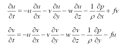
I am not saying that will happen…we need to get the shortwave trough moving in the SW US tomorrow morning, and see how far south the cold air makes it tomorrow. That will give us a better idea on where a low might form, how strong (close to the coast the stronger), and just how cold it will be here). There are certain ways that people can’t beat models, in that they do literally millions of calculations of complex equations like the ones below, at a spot about every 10 square miles, every 1 to 5 minutes, at dozens of vertical levels, to forecast what will happen. I understand the equations, but I can’t possibly think through all of that in my head. However, models are prone to biases and problems (see chaos theory and the fact that we don’t have a balloon sounding at every city in the world every hour), and we as meteorologists have to examine the patterns as they develop, and look at what should happen.
I’ll have more tomorrow on how upper-level disturbances work, and how they interact with cold fronts to produce low pressure areas, and how those two sometimes have a positive feedback on each other to produce big storms, and other times nothing happens. Some good old Meteorology lessons.
My bottom line right now…I still don’t know. There is such a large spread in the models, and the cold air is coming in so fast tonight, that I need another day (Thursday) to look at it. I get to say that…James has to put out a forecast…and I think his is as good as possible, and most likely to be right on. So, read his forecast.
(u and v are the eastward and northward components of the wind, t is time, x and y are distance east and north, w is vertical motion, z is up, rho is density. p is pressure, f is the Coriolis parameter) And these are just the equations for horizontal wind, and some terms that play a small role (friction, earth curvature terms, etc.) have been left out. There are similar equations for vertical motion, temperature, pressure, humidity, and others.
Category: Winter Weather


